

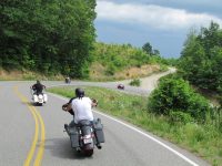
Cherokee National Forest-43 Miles-NC & TN
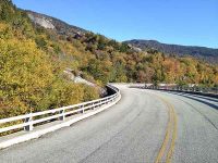
The Cherohala Skyway motorcycle ride is a thrilling and awe-inspiring adventure that takes riders on a breathtaking journey through the mountains of Tennessee and North Carolina. This 43-mile scenic byway offers a perfect blend of sweeping curves, stunning vistas, and pristine wilderness. As riders ascend the Cherohala Skyway, they are treated to panoramic views of the Great Smoky Mountains and the Cherokee National Forest. The road itself is well-maintained and offers smooth pavement, making it a dream for motorcycle enthusiasts seeking a thrilling and enjoyable ride. Along the way, riders can stop at various overlooks and pull-offs to take in the majestic beauty of the surrounding landscape, including waterfalls, rivers, and dense forests. The Cherohala Skyway motorcycle ride is an unforgettable experience that combines the thrill of riding with the tranquility of nature, making it a must-do for any motorcycle enthusiast.
Get your souvenirs here… T-shirts, patches, pins, and more at motorcycleridershop.com


Casual counter-serve chain for build-your-own sandwiches & salads, with health-conscious options.
Since 1954, McDonald’s has been dedicated to serving quality food and quick service at an affordable price for our customers. Visit your nearby McDonald’s and choose from a full menu of favorites, including McCafé® coffee, All Day Breakfast, juicy burgers like our Quarter Pounder®* with Cheese and more!
Restaurants nationwide offer numerous amenities to ensure every customer has an enjoyable experience. Find out if your local nearby McDonald’s is open 24 hours, offers drive thru or McDelivery®**, has a PlayPlace and more from our restaurant locator. Plus, order ahead in the App and get your food when you arrive at the restauraunt with Mobile Order and Pay†, available exclusively on the McDonald’s App!
Next time you’re looking for a tasty treat, head to a McDonald’s nearby. For information on deals, download the McDonald’s App today!
*Weight before cooking 4 oz.
**At participating McDonald’s. Value menu and promotional pricing not valid for delivery. Delivery prices may be higher than at restaurants. Uber Eats delivery fee, service fee and small order fee apply. See Uber Eats app for details.
† McD App download and registration required. Mobile Order & Pay available at participating McDonald’s.
Two Rivers Lodge is an American,family owned,nostalgic,Mom & Pop Motel on the on the Oconaluftee and Tuckaseegee Rivers. We provide a relaxing casual environment from our homey rooms,deep porches, and outdoor spaces to our large pool and kiddy pool. This is the perfect base camp for your motorcycle group,sports car club,family reunion,river adventure or hiking trip with easy access and central location to all of the best roads and attractions. We provide memorable experiences. Great Reviews !
Iron Horse Motorcycle Resort is located in western North Carolina, this secluded, 39-acre resort on Stecoah Creek is surrounded by the beauty of the Great Smoky Mountains. The area has some of the best motorcycle riding in the world.
Iron Horse is minutes from the famous Tail of the Dragon at Deals Gap, the scenic mile-high Cherohala Skyway, Moonshiner 28, Blue Ridge Parkway, Cherokee, Fontana Dam, and the Nantahala River Gorge. Whether you are on a cruiser, sport bike or dual sport, Iron Horse is where riders stay and play.
Reflecting the free spirit of the old west and of modern motorcyclists, Iron Horse is designed with a western flair offering a wide range of accommodations and facilities, including motorcycle camping.
Nestled in the heart of the Great Smoky Mountains of Bryson City, NC, Nantahala Village Resort is the ideal North Carolina vacation and Cabin Rental destination – perfect for romantic getaways, family vacations, weddings, and group events. Choose from a variety of lodging options including well-appointed Lodge rooms, mountain suites, and cozy rental cabins. We offer complimentary bagged breakfast including a granola bar, muffin, apple, bottle of water and a juice carton. Call Nantahala Village Resort for details. Should you wish to explore this beautiful Smoky Mountain area, there are whitewater rafting outfitters, zip-lines, miles of hiking and biking trails, premier trout streams, The Smoky Mountain Railroad, Bryson City shopping and Bryson City dining just minutes away. Or test your engines on the Tail of the Dragon, Cherohala Skyway or many other nearby scenic mountain roads. Visit the towns of Bryson City and Cherokee for authentic handcrafts, dining and historic experiences.
Nantahala Village Resort was established in 1948, when the Great Smoky Mountains National Park was new and a visit to the western North Carolina Mountains was a true retreat from the world. Now over 60 years later, Nantahala Village Resort continues to provide an opportunity for family and group getaways. With our variety of lodging choices, full service restaurant, indoor and outdoor meeting spaces, swimming pools, game room, fitness center and horseback riding the Village caters to individuals and groups.

We are nestled deep in the Great Smoky Mountains on the NC/TN state line and are known as the home of “The Dragon” motorcycle ride with over 318 curves in 11 miles. We are open from March 1st through late November and provide you with all of the amenities needed for a comfortable overnight stay. You will find many scenic and beautiful places to stop and take in all of the natural beauty that our area has to offer. Without a doubt, you will have one of the best motorcycling experiences one could have
Looking for a vacation that’s a little different, a little more, a little better than your last one? That’s why we’re here. At Sky Ridge, we strive to give our guests a place where they can relax and reconnect with themselves and with nature without giving up the comforts of home.
Perched high atop a mountainous ridge line with a view that will take your breath away, you’ll find seven well-appointed yurts ready and waiting for you and your friends and family to experience the Great Smoky Mountains in a completely new and changing way. You just might not want to leave.
Two Rivers Lodge is an American,family owned,nostalgic,Mom & Pop Motel on the on the Oconaluftee and Tuckaseegee Rivers. We provide a relaxing casual environment from our homey rooms,deep porches, and outdoor spaces to our large pool and kiddy pool. This is the perfect base camp for your motorcycle group,sports car club,family reunion,river adventure or hiking trip with easy access and central location to all of the best roads and attractions. We provide memorable experiences. Great Reviews !
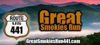
Newfound Gap Road-42 miles-Cherokee to Gatlinburg
The GreatSmokiesRun441.com is a 42-mile motorcycle ride must for those who visit the Blue Ridge Mountains, and everyone here knows the Newfound Gap Road Route 441 from the town of Cherokee North Carolina the main route through the Great Smoky Mountains National Park connecting to Gatlinburg. The GreatSmokiesRun441 motorcycle route is a great run for beginners and is at an elevation of over 5,000 feet, it is still great for a quick climb into the forest where you can get lost in the trees and tunnels. There are a few switchbacks that are easy to navigate due to the national park speed limit. The Great Smoky Mountains National Park is among the most visited national parks in the world! The route goes through many altitude changes and offers plenty of striking views. As you travel down the road, you’ll find plenty of scenic pullouts that provide beautiful sights of the mountains. When you reach Clingman’s Dome, you’ll be at the highest point in Tennessee. You can look over a dozen mountain ridges when you look east on a clear day.
Get your souvenirs here… T-shirts, patches, pins, and more at motorcycleridershop.com

469 Miles-Beautiful Mountain Vistas-NC and VA
The Blue Ridge Parkway begins at Milepost 0 between Waynesboro and Afton in Virginia and ends 469 miles away in Western North Carolina in the Great Smoky Mountains National Park.
The Blue Ridge Parkway is 469 miles of pristine beautiful mountain vistas known worldwide for its preservation, greenery, fall colors and outdoor recreation for all ages. The Blue Ridge Parkway averages 20 million visitors, tourists, and travelers per year. Visitation builds during the spring and summer and peaks in the months of October when the fall leaves changes the parkway into a beautiful kaleidoscope of colors.
Get your souvenirs here… T-shirts, patches, pins, and more at motorcycleridershop.com
The highest and longest continuous route in the Appalachians, the Blue Ridge Parkway runs for 469 miles through North Carolina and Virginia. It has 26 tunnels, 168 bridges, and 6 viaducts. The Southern end of the Parkway is just 10 miles from Bryson City at Milepost 469. The 90 miles between there and Asheville is thought by many to be the most scenic. There are many overlooks where you can stop and enjoy the amazing vistas, and the Parkway has a 45 MPH speed limit which makes this ride very relaxing.
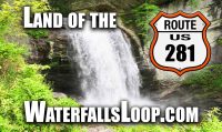
Blue Ridge Parkway – Pisgah National Forest – 186 Miles – 13 Waterfalls- Maggie Valley, Franklin, Dillsboro, Cashiers, Highglands, Rosman, Brevard, Waynesville
The Land of the Waterfalls Loop motorcycle ride is a scenic and exhilarating journey through the lush landscapes of North Carolina, showcasing the beauty of numerous cascading waterfalls along the way. The LandoftheWaterfallsLoop.com is a tour of 13 roadside waterfalls on this long and scenic spectacular day ride. The motorcycle ride starts in Maggie Valley to Cherokee to Franklin, then to Highlands. Riders will be treated to winding roads, picturesque mountain views, and the soothing sounds of rushing water as they navigate this popular route. Highlands to Cashiers on to Rosman then to Brevard then onto US 276 to the Blue Ridge Parkway to NC 215 then follow it back to US 276 and into Maggie Valley. 186 miles. All day ride. With opportunities for sightseeing, hiking, and exploring charming small towns, the Land of the Waterfalls Loop offers a perfect blend of adventure and relaxation for motorcycle enthusiasts seeking a memorable two-wheeled experience in the heart of nature.
Get your souvenirs here… T-shirts, patches, pins, and more at motorcycleridershop.com

They are known as the “Museum That Runs” because of their unique goal of offering their visitors an experience unlike any other by starting some of the motorcycles daily. This is home to the world’s foremost All-American Vintage Motorcycle Collection, with over 300 historically important motorcycles displayed in 24 marquees.
Wheels Through Time Museum is home to the world’s premier collection of rare American motorcycles, memorabilia, and a distinct array of unique “one-off” American automobiles. Located just 5 miles off the Blue Ridge Parkway in Maggie Valley, North Carolina our museum houses a collection of over 300 rare machines.

Complete end-to-end coverage of the Blue Ridge Parkway, north Georgia, and Great Smoky Mountains National Park in a series of easy to fold pocket maps which show EVERY great ride in the mountains. I seek out the best two lane mountain back roads then show you the best ways and shortcuts to link them all together.
Stay on the best roads, see the best sights. We focus on ALL the good roads, not just the well known tourist routes. Of course you’ll find detailed coverage the famous named routes like the Dragon, The Blue Ridge Parkway, The Cherohala Skyway, etc., but you don’t have to ride a hundred miles on the highway to get to the next great road – we show you the good connecting roads so you can stay on the backroads and avoid the highways and towns and see the hidden sights most others miss.

Lake Junaluska to Hot Springs- 234 Curves-33 miles
The Rattler Route 209 motorcycle ride North from Lake Junaluska to Hot Springs is a thrilling journey through the scenic beauty of North Carolina on route 209. Riders will experience the winding roads and breathtaking views as they traverse through the Great Smoky Mountains. The route offers a perfect balance of challenging twists and turns, as well as opportunities to appreciate the serene surroundings of Lake Junaluska and Hot Springs. There are over 234 twists, turns S-turns, switchbacks and curves on the Rattler 209 in 33 miles and is just as difficult as the Tail of the Dragon, The Snake and many other motorcycle rides for testing your riding skills.NC-209 is well maintained and less traveled than many of the other motorcycle routes. Nevertheless, it is well worth the time it may take to get there. It is a great ride. Whether you’re a seasoned rider looking for an exciting adventure or a nature lover seeking a peaceful escape, the Rattler Route 209 promises an unforgettable experience for all who embark on this unforgettable ride.
Get your souvenirs here… T-shirts, patches, pins, and more at motorcycleridershop.com
Chattahoochee Forest-50 Miles-Best Ride in Georgia
TheGeorgiaDragon.com motorcycle ride is located in the Chattahoochee National Forest and the Blue Ridge Mountains of Northern Georgia with its 50.5 miles of twisties, curves and magnificent scenery is definitely one of the best motorcycle roads in Georgia. For my motorcycle rides we will go with the local name aka Georgia Dragon as I have another great ride called the SuchesLoop.com. Seasoned Motorcycle riders will find the road challenging due to the elevation changes. Take this ride a bit slower to enjoy the spectacular scenery. TheGeorgiaDragon.com motorcycle ride starts in the town of Dahlonega (First major US town gold rush back in 1828) and runs north on Route 60, then merging with US-19 and then turn right on to Route 180 called Wolfpen Gap Road steep elevation changes and switchbacks. The ride continues through the mountains to US Highway 129/19. Then make a right and head south back to Dahlonega to complete the Georgia Dragon!
Get your souvenirs here… T-shirts, patches, pins, and more at motorcycleridershop.com

North Georgia Mountains-140 Miles-Elevation Changes
TheSuchesLoop.com motorcycle ride is an extended larger loop than the TheGeorgiaDragon.com. Some of theSuchesLoop.com motorcycle run highlights are riding through and nearby the following: Vogel State Park, Blood Mountain, Dahlonega, Etowah River Falls, Dawsonville, Blue Ridge, and Morganton just to name a few.
TheSuchesLoop.com is packed with s-curves, blind corners, steep elevation changes, twisties and magnificent scenery and is one of the best motorcycle roads in Georgia right smack in the middle of the impressive Chattahoochee National Forest and Blue Ridge Mountains. Experienced motorcycle riders will find the road challenging due to the elevation changes but suggest that new riders to the area and the ride take it slower to enjoy the spectacular mountain roller coaster of scenery.
The scenery is worth taking your time with rolling, lush valleys and thrilling switchbacks across ridges and roads such as Wolf Pen Gap, Route 19, Route 180, and Route 60. There are many great places to make a basecamp for riding in Northern Georgia.
Get your souvenirs here… T-shirts, patches, pins, and more at motorcycleridershop.com
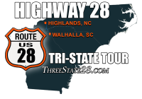
Walhalla SC – Highlands NC – 30 Miles-3 States
The ThreeState28.com motorcycle ride Start in Walhalla, SC and head north on route 28 for 32 miles. Cross the SC/GA border, stay on route 28, cross the GA/NC border, and head into Highlands, NC. Blacktop S turns, sweepers and hairpins wind up and down the hills with glimpses of the mountains and the valleys throughout the ride along with twisties and elevation changes. This ride runs through the Sumter and Nantahala national forests with mountains, rivers and waterfalls and crossing through three states. Not a lot between Walhalla and Highlands, so, fill up before you leave Walhalla. No restaurants or other facilities for miles.
There are three rides on highway 28, the first section riding from South to North is the ThreeState28.com. This motorycle ride is 32 miles from Walhalla SC to Highlands NC, the second part is the Moonshiner 28 from Highlands NC to Franklin NC and the thrird part is TheHellbender28.com is from Franklin NC To Deals Gap NC 22 miles.
Get your souvenirs here… T-shirts, patches, pins, and more at motorcycleridershop.com
If you’re intrigued by the idea of traveling eastern Tennessee’s patchwork of two-lane roads, plan to take on “The Devil’s Triangle” this season. This memorable 72-mile route, winding through Tennessee’s Cumberland Plateau, is meant for experienced riders ready for the region’s simply maintained roads and challenges around every curve.
If you enjoy traveling gently curving rural roads dotted with houses, farm scenery, and random ATV’s, you’ll find those vistas here. On the other hand, you’ll encounter plenty of switchbacks and twisted turns that closely resemble The Dragon’s challenges.
As an added bonus, The Devil’s Triangle throws in roadside rock-filled gullies, impressive rocky cliffs, mangled guardrails, and rutted roadways. Keep a watchful eye for trucks, as some parts of the route don’t leave much room for pull-offs and other evasive maneuvers. Finally, let’s not forget the route’s notorious climbs – including at least one section with a 1600-foot change in just 1.5 miles.
Finally, you won’t find competing tourist attractions along The Devil’s Triangle route. However, you will encounter the now-closed Brushy Mountain State Penitentiary, a notorious regional facility that opened in 1896 and closed in 2009. This maximum-security prison, located in a nondescript two-story building, held the “worst of the worst” criminals during its lifetime. Today, travelers are invited to tour the prison, visit the facility’s museum, and buy some “End of the Line” Tennessee moonshine (which is actually distilled and bottled onsite). Paranormal tours are also available – if you dare.

Pisgah National Forest-81 Miles in NC-8 Waterfalls
The Copperhead motorcycle ride is a thrilling and scenic route that takes riders through the beautiful landscapes of North Carolina. This ride is known for its winding roads, breathtaking views, and challenging terrain. The ride start in the North Carolina Town of Brevard, southwest of Asheville, and continues in the Pisgah Forest on Route 276 NC. The first waterfall you must stop at the famous Looking Glass Falls. After taking some photos you will know what this ride is about. Water and the twist and turns like a Copperhead Snake.
Riders can expect to navigate tight curves and steep inclines as they make their way through the picturesque mountains and forests of Woodrow NC down Route 215 NC towards Rosman. Along the way, they can take breaks in charming towns, enjoy local cuisine, and soak in the natural beauty of the area and experience many more waterfalls and waterfall hikes.
The Copperhead motorcycle ride offers an exhilarating experience for riders seeking both adventure and stunning scenery.
Get your souvenirs here… T-shirts, patches, pins, and more at motorcycleridershop.com

160 Curves-12 Miles-Elevation rise 2000 ft.
The Devil’s Whip Route 80 motorcycle ride is an exhilarating and adrenaline-fueled journey that takes riders through the captivating landscapes of North Carolina. Trucks are not allowed and there is a sign stating, “Steep Winding Road”. This ride is known for its twisty and challenging roads, making it a favorite among motorcycle enthusiasts seeking an exciting adventure. This road is 12 miles with 160 curves, some switchbacks, and rising in elevation 2000 feet in those 12 miles. The Devil’s Whip Route 80 offers riders a thrilling experience as they navigate through tight hairpin turns, steep inclines, and breathtaking mountain views. As riders conquer the winding roads, they will be rewarded with awe-inspiring scenery, including lush forests, cascading waterfalls, and panoramic vistas. Whether you’re a skilled rider looking for a thrilling challenge or a nature lover seeking to immerse yourself in the beauty of North Carolina, the Devil’s Whip Route 80 motorcycle ride promises an unforgettable journey filled with excitement.
Get your souvenirs here… T-shirts, patches, pins, and more at motorcycleridershop.com